SOURCE-CHECKED · APPS & THE WEB
Google Maps Measure distance: draw a path and read the total
Draw straight segments with Google Maps Measure distance, edit the points, and use a three-point ruler to understand why an extra point changes the total.
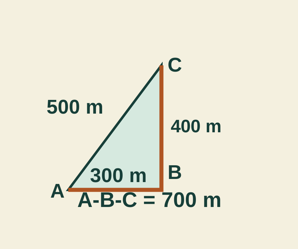
On a computer, you can use Measure distance to draw a line with several segments and read their combined length. It measures the line you draw, so an extra point changes the total.
Draw and adjust the line
Right-click your starting point in Google Maps and select Measure distance. Click the next point, then keep clicking to add segments. The card at the bottom shows the total in miles and kilometers. You can drag a point or the path to adjust it, click a point to remove it, and select Close when you’re done. Measure distance is unavailable in Lite mode, indicated by a lightning bolt. These are the steps in Google Maps Help.
Check what the total includes
Open the three-point ruler and select Add A, Add B, then Add C. Its points are A at (0, 0), B at (300, 0), and C at (300, 400), in meters. A-B is 300 meters and B-C is 400 meters, so the line A-B-C totals 700 meters. The single segment A-C is 500 meters. Adding A again to close the triangle makes the total 1,200 meters.
After the three-point example, select Add A to close the loop, or Reset and select Add A followed by Add C to compare the direct line. Undo last point removes the most recent entry. The ruler calculates this fictional flat triangle; it does not connect to Google Maps.
If your goal on a map is to measure just the two endpoints, inspect the whole point list or drawn line for an unwanted bend. In the triangle, removing B from A-B-C leaves A-C. That changes the drawn line’s total from 700 to 500 meters. The coordinates illustrate the arithmetic; they are not a real location measurement.
Use Directions for travel
Measure distance adds the segments you place. For a trip, use Google Maps Directions, where you choose a travel mode such as driving or walking. If you need to arrange destinations on a trip, see the guide to multiple stops.
Source note: The Google Maps Help steps were checked October 11, 2026. The triangle totals were calculated from the stated coordinates; the ruler’s arithmetic and controls were checked in a browser. No Google Maps distance measurement or travel route was independently tested.
KEEP GOING
More to explore.
SOURCE-CHECKEDApps & the web
Find wheelchair-accessible transit options in Google Maps
Google documents a transit route option on computers and Android. Its Android guidance also explains place attributes, which are available only in certain countries.
TESTEDApps & the web
How to add multiple stops in Google Maps without losing the visit order
Adding a museum after the finish made it the new final stop. See how Google Maps visit order works, with a real four-place check and reusable route links.